Submitter: (ICRISAT)
Digital technology for monitoring water bodies and soil and water conservation structures refers to the use of advanced tools and systems—such as geographic information systems (GIS), drones, sensors, and satellite imagery to collect, analyze, and manage data related to water resources and conservation efforts. These technologies enable real-time tracking of water levels, erosion patterns, and the condition of conservation structures like check dams, terraces, and bunds. By retrieving accurate and timely information, digital tools help optimize water use, and support better planning and maintenance of natural resources for sustainable agriculture and environmental management.

Digital technology for monitoring water bodies and soil and water conservation structures includes tools like satellite images, maps (GIS), sensors, drones, sensors and data analysis software. Satellites and drones help see large areas and check water levels or soil conditions. Sensors placed in fields/water bodies measure moisture and water flow. This helps farmers and managers spot problems early, like low water or damaged structures, and fix them on time. Overall, it supports better water use, protects soil, and improves farming.
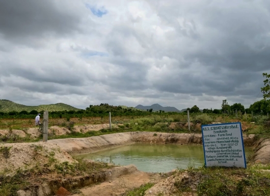
Digital technology for monitoring water bodies and soil and water conservation structures is currently used and has great potential in regions where water scarcity and soil erosion pose significant challenges. For example, ICRISAT has successfully applied these advanced tools in central and eastern India to map and design various water harvesting structures. By using state-of-the-art instrumentation and remote sensing techniques, ICRISAT has been able to estimate the volume of water storage (fillings) in these structures under different conditions of rainfall, soil type, and land slope. This detailed data helps in prioritizing areas that need urgent intervention and supports better planning of conservation efforts.
Moreover, the technology provides valuable insights into how water availability and soil conservation vary across both space and time, enabling more precise management of natural resources. By understanding these patterns, stakeholders can optimize the placement and design of structures like check dams, ponds, and terraces to maximize their effectiveness. This approach not only improves water use efficiency and soil health but also enhances agricultural productivity and resilience in vulnerable agroecological zones.
Digital technology for monitoring water bodies and soil and water conservation structures has shown significant positive results in improving water management and soil conservation efforts. In regions like central and eastern India, where ICRISAT has implemented these tools, the accurate mapping and analysis of water harvesting structures have led to better design and placement, resulting in increased water storage and reduced soil erosion. This has helped farmers and communities optimize water use during dry periods, improving crop yields and reducing vulnerability to drought. The ability to estimate water fillings under different rainfall and soil conditions has also enabled more efficient prioritization of intervention areas, ensuring resources are used where they have the greatest impact.
The technology’s flexibility allows customization based on local soil types, rainfall patterns, and terrain, enabling targeted and efficient resource management at scale. To adopt and scale this technology successfully, strong collaboration is needed between governments, research institutions, and local communities to share data and expertise. Reliable access to high-quality satellite and sensor data, along with investment in infrastructure and data processing capabilities, is essential. Training and capacity-building for local stakeholders to interpret and use the data effectively is also critical. Finally, supportive policies and funding mechanisms will help ensure long-term sustainability and widespread adoption in vulnerable regions.
Venkataradha, venkataradha.akuraju@icrisat.org
Sourav Roy: Sourav.roy@icrisat.org