Submitter: (ICRISAT)
LULC (Land Use Land Cover) mapping helps to identify different landuse and landcover by natural or human interventions. LULC mapping helps in identifying hotspots of environmental degradation, such as deforestation, seasonal and permanent fallow, rainfed and wasteland areas. LULC information supports better planning and management of natural resources, helps target conservation efforts, and informs policies aimed at sustainable land use and climate change mitigation by providing accurate and real-time information.
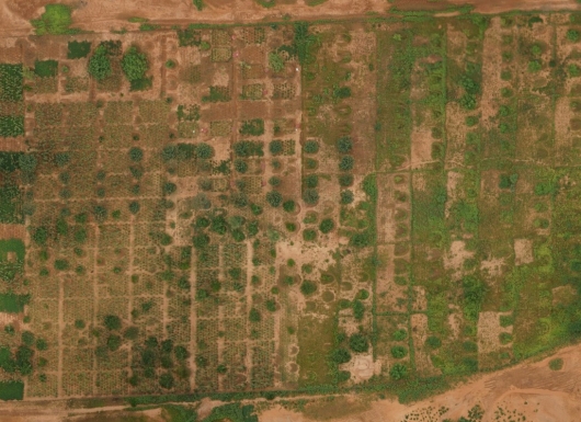
The main components of Land Use and Land Cover (LULC) mapping include the acquisition of satellite imagery or aerial photographs, image processing, ground-truthing, and the classification of images into various land use and land cover types. Image processing software is used to analyze and classify this data into categories such as forests, agricultural land, urban areas, and water bodies. Various algorithms and techniques in image processing and classification help analyze changes over time by comparing images from different periods. Accuracy assessment is a crucial aspect of LULC mapping and can be achieved using subsamples from ground-truthing data. LULC mapping is useful because it offers a clear understanding of how land is being used and how it changes, which is essential for identifying environmental hotspots like deforestation and extend of land degradation. It supports impact assessment by revealing the extent and effects of human activities and natural processes on ecosystems and resources. This information helps policymakers, planners, and environmental managers make informed decisions for sustainable land management, conservation, and climate adaptation
LULC mapping is widely used and has strong potential in regions facing rapid land use changes and environmental challenges. It is also applied in watershed and forested areas prone to degradation and biodiversity loss. Potential target regions extend to drylands and semi-arid zones vulnerable to drought. Agroecologies that gain most from this technology include mixed farming systems, forest-agriculture, and regions with fragile ecosystems where monitoring land cover changes is critical for resource management and climate resilience.
ICRISAT uses LULC mapping to study and manage landscapes in different regions. A key example is rice-fallow mapping, which estimates the area of fallow land after harvesting rice crop that can be used for additional crops to boost productivity. ICRISAT also analyzed the impact of Eucalyptus plantations on ground water in Kolar district, showing how this land use change affect the local water budget and other cropping systems. These studies help guide better land and water management decisions for sustainable agriculture and resource conservation. Impact of landuse change in Kolar district, Karnataka: https://doi.org/10.1016/j.ejrh.2020.100732
LULC mapping can be scaled because it relies on widely available satellite imagery and cost-effectiveness. The growing availability of high-resolution data and improvements in remote sensing technology further support scaling. To adopt LULC mapping successfully, there is a need for technical expertise in remote sensing, data analysis and interpretation, reliable access to up-to-date satellite data. Training local stakeholders and decision-makers to use and apply the information is crucial. Supportive policies and collaboration between government agencies, research institutions, and local communities will also help ensure effective adoption and sustained use.
Murali K Gumma
Email: muralikrishna.gumma@icrisat.org
Venkataradha Akuraju
Email: venkataradha.akuraju@icrisat.org