Submitter: (ICRISAT)
Crop type mapping and crop health assessment are essential components of modern agricultural monitoring. Crop type mapping involves identifying and classifying the various crops grown in a region using satellite imagery, remote sensing, and GIS tools, which helps in understanding cropping patterns and planning agricultural activities.
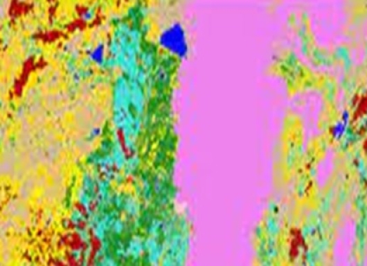
The main components of Crop type mapping include the acquisition of time-series hyper-spectral satellite imagery, ground-truthing, building spectral libraries for different crops, image processing, and estimating the area under different crops. The benefits of crop type mapping include improved agricultural planning, as it supports decisions related to crop rotation, yield forecasting, and market supply management. Governments and insurance providers can leverage this data to verify crop insurance claims and manage subsidy programs more effectively.
Crop type mapping and crop health assessment have already successfully deployed in a variety of agricultural regions in India with established access to satellite data and digital agriculture infrastructure. This can be expanded to regions where agriculture is critical to livelihoods, but data-driven farming is still emerging. This includes much of Sub-Saharan Africa, South and Southeast Asia. These areas often have high climatic variability and fragmented landholdings, making remote sensing tools valuable for scalable, consistent monitoring. and farming systems worldwide, demonstrating their adaptability across diverse agroecological zones.
Crop type mapping and crop health assessment have already successfully deployed in a variety of agricultural regions in India with established access to satellite data and digital agriculture infrastructure. This can be expanded to regions where agriculture is critical to livelihoods, but data-driven farming is still emerging. This includes much of Sub-Saharan Africa, South and Southeast Asia. These areas often have high climatic variability and fragmented landholdings, making remote sensing tools valuable for scalable, consistent monitoring. and farming systems worldwide, demonstrating their adaptability across diverse agroecological zones.
Crop type mapping and crop health assessment technologies are highly scalable due to their reliance on widely available satellite and drone imagery, cloud computing, and advanced machine learning algorithms. These solutions can be adapted to various geographic regions, crop types, and farm sizes, from smallholder farms to large commercial operations. To successfully adopt these technologies, key requirements include access to quality geospatial data, basic technical infrastructure such as internet connectivity, and training or capacity-building for end-users to interpret and apply the insights effectively. Collaboration with local agricultural extension services, technology providers, and government agencies further facilitates adoption by aligning solutions with local farming practices and policy frameworks.
Murali K Gumma
Email: muralikrishna.gumma@icrisat.org
Srikanth Rupavatharam
Email: srikanth.rupavatharam@icrisat.org